City Modeling
Modeling Terrain
In our conceptualization of site, Terrain has several critical characteristics and roles.
Conceptual Model
- Terrain slopes and aspects are involved with the logic of the site plan, including circulation, program and plantings.
- Terrain determines and is determined by drainage and water accumulation patterns, planned and unplanned.
- Terrain, along with buildings and plantings creates and screens visual linkages across and out of the site.
Data Model for Terrain
A useful model for terrain will provide us with an efficient way to control the terrain surface that will allow us to affect the shape a in a predicatble way without excess effort. We often think of Contours as such a descriptive language -- yet it is more true that contours and drainange lines provide a very useful 2D visual portrayal of a terrain surface. There are common things that happen in sites that is very difficult to represent with contours. And not all contours are equally important. If a person tries to control the shape of a surface by manipulating a complete contour map. She will find herself spending 90 percent of her time fiddling with infomration that is actually of no consequense in determining the shape and performance of the surface. What is needed is a set of gestures that describe those critical places in the terrain where there are breaks in grade, peaks, ridges and valleys. Once we have interpolated our controls into a logical surface, we can us it to generate contours at any interval we need.
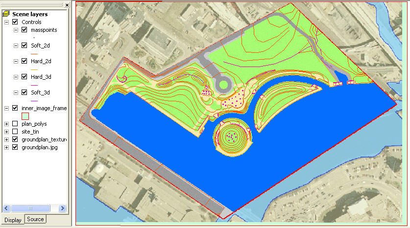 |
Terrain Controls Referencing Groundplan. Detail 1, Detail 2, Interpolated Surface with Draped Groundplan Image. Detail With Edges Another Detail. Detail 2 with edges. |
To take a tour of this model yourself Download this file and open the docs/arcschene2.sxd document.
Constrined Delaunay Triangulation
Civil engineers have long understood an efficient conceptual vocabulary for describing and manipulating virtual terrain surfaces. This alphabet of Hard and Soft Breakines and Spot Elevations provides a very efficient means of indicating the citical aspects and relationships of a terrain surface. Understanding this efficient language of surface behavior provides us with a very effective way of creating and modifying terrain surfaces that we can evaluate. There are only a few tools that provide interfaces, interpolators and analytical tools that use this vocabulary.
Delaunay Triangulation is an algorithm for interpolating values between points. The Rhino Pointset Reconstruction tools perform delaunay trangulation using points alone. This works OK when you have a regular array of points. But when your point spacing is not regular, such as what you would get when you use the vertices of contours, odd thhings can happen, especially when the interpolator decides to connect points that are on oposite sides of a contour. This violates the logic of contours. The simplest sort of Constrained Interpolation takes the contour lines as constraints and prevents interpolation to happen across contours. While contours are always planar by definition, a good delaunay interoplator can also use 3d breaklines as constraints. The best Delaunay Interpolators can also allow for Hard and Soft Breaklines Here is a Nice page about delaunay interpolation from Spatial Techniques.
